DISCLAIMER: This post was written in 2012. Information may be out of date!
Location: Taman Saga, Cheras/Ampang, Malaysia.
Start point: 3.113788N, 101.773276E 149m a.s.l.
End point: [Varies] Highest point – 3.111677N, 101.779017E 342m a.s.l.
Difficulty: Easy. Recommended for beginner hikers. The only danger is getting lost amongst the huge network of trails.
Saga Hill (Bukit Saga) is actually just one peak of many on a hill with a large, flat top, near Cheras. After the many mountains that I have been climbing, Saga Hill is definitely a very easy climb, with well maintained trails and a reachable summit of ~430m. There are many routes to choose from, which start from various sides of the hill. Saga Hill refers to the hilltop nearest the small town of Taman Saga, where the starting point is. (Another popular route starts from Cheras Awana, where the hill is called Apek Hill) Don’t expect any good views of the surrounding area, as there are always lots of trees blocking the view. If you want a view close to PJ/KL, I suggest Bukit Tabur or Broga Hill. It is actually possible to become lost at Bukit Saga due to the huge network of trails which join the various peaks and climbing routes together. A few of the major trails are marked, but it’s probably a good idea to remember which trails you go on, or, like me, use GPS to record your trail so that heading back is an easy task.
I’ve climbed Saga Hill twice in the past (I never blogged about them), but always took the same route. For this 3rd time, me & my friend decided to check out the waterfall, and take a different route down. I was there for a very relaxed hike as I had 2 big climbs coming up the next week, while my friend was there to train for Mt. Ophir (Gunung Ledang). Thus, he filled up his bag with 12kg of weights and water, so that we would get different amounts of exercise at the same pace.
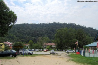
The residents (many of which are more senior and like to climb every day) apparently prefer that climbers don’t park too near their houses, so the suggested parking space is a small park in front of a kindergarten (I think). From there, Saga Hill is clearly visible.


After passing the small waterfall at the start, there are 3 routes to choose from.
Route A is the shortest, and possibly the most popular. Since it is the shortest, it is also the steepest, but has a huge amount of tree roots along the way, which make it easy to find places to step and does not become slippery. There is also a short rope climbing section (up some rocks), which can be bypassed.


Route B – I have yet to climb this. I’ll fill up this section once I’ve done so!
Route C is slightly longer than route A, and is less steep, and in my opinion, slightly easier. However, shoes with decent grip helps a lot as the ground is bare, so it may be challenging at times to find grip (Similar to Broga Hill). I personally found no issues with my hiking shoes, climbing after a heavy rain, so I’m not sure why people call this ‘Route C-hallenging’.

I can’t remember if there’s a Route D anywhere, but I think I remember hearing of it once.
Saga’s hilltop has no view, but contains a large number of benches/tables, exercise equipment, and even a ‘changing room’ of sorts. From there, you can head to a small waterfall, which is less than an hour away. Some people argue whether it’s worth the hike.

Between Saga’s hilltop and Route C lies a beirut (I’m still not sure where the term comes from), which presumably marks the highest point of Saga Hill.

There’s much to explorer at Saga Hill, as long as you’re not interested in views which look out, which are pretty much nonexistent. However, Saga Hill provides a decent amount of exercise while still being relatively close to PJ/KL (Of course, driving there is not always as pleasant, in my experience)
GPS Details
Download GPX, KMZ (Google Earth)
View on EveryTrail
Duration: 3 hours 25 minutes
Length: 5.5km
Average Speed: 1.6km/h
Max elevation: 432m
Min elevation: 148m
Vertical Up: 557m
Vertical Down: 560m


Hey
How did u get the graph of height n speed vs distance?
Can iphone do that?
Of course. There are a few apps that provides such data.
Hey, thanks. this is very informative
trekz & trailz of apek hiLL
https://www.google.com/maps/d/edit?mid=zI0PXvheisYA.kYv4wZWbF4IE
Is there a ticket to get inside? If yes how much does it charge?
What application did you use to track down your route?
comel sangat dah ini gunung