Broga Hill for the 4th time

My 4th trip to Broga Hill near Semenyih, Selangor. Total hiking time is under an hour, and is suitable for beginners. The reward to work ratio is very high, as there are great views from the summit. It can be very crowded on weekends/public holidays, and unfortunately, garbage is littered all along the trail.

DISCLAIMER: This post was written in 2012. Information may be out of date!

Location: Broga/Semenyih, Selangor, Malaysia.
Start point: 2.938412N, 101.901154E 105m a.s.l. (Opposite Rabbit Fun Land)
Summit: 2.950264N, 101.903020E 396m a.s.l.
Difficulty: Easy. No technical skills required. Trail is not steep, but can be slightly slippery especially after rain. Good place for beginner hikers.

Date climbed: Tue 21 Aug 2012

This was my 4th trip to Broga Hill, which is famous for its lack of trees (It’s also known as the “Lalang” [long grass] Hill), and its good view of the surrounding area, given the relatively easy climb. Unfortunately, its popularity means that the trail is very worn, and there is a lot of rubbish littered along the trail. Additionally, it can be crowded on weekends and public holidays. In fact, on my 2nd trip there, our group was stuck in a constant human traffic jam all the way up to the summit, which upon arriving was so jam packed that we had no place to stand.

On this particular visit, it was busy, but not the worst. I went there to show a few of my friends around. My friends are all good hikers, in better shape than me, but it was their first time, and one of them was to lead another group of people a few weeks later. The climb takes between 30min to 1hr to climb, and since it is an easy trail, we decided to bring along a bag of charcoal and some food (sausages and Ramly burgers) to cook on the summit.

Parking costs RM2, and is located just opposite Rabbit Fun Land. From there on, the trail is very clear. Just remember to keep right at the fork ~5min from the car park (It’s the path which goes up in elevation). From there, you’ll walk through jungle for about 15-20min until you emerge at a steep climb to the 1st summit. From the 1st summit, you can hike onwards to the 2nd, 3rd, and 4th summit. The 4th summit requires a short rope section where you have to pull yourself up a few boulders. At the summit (396m), you can hoist yourself up the big boulders if you want to, or continue on to Gunung Tok Wan (which we didn’t). There are a few bees around the summit which you want to watch out for. In fact, on my 3rd trip there, one of us was stung and we were chased all the way down to the 2nd summit by other bees!

If you do climb Broga, please do other people a favor by bringing a few garbage bags and collecting the garbage on your way down. Yes, it’s not our garbage, but it will hopefully make the climb nicer for others.
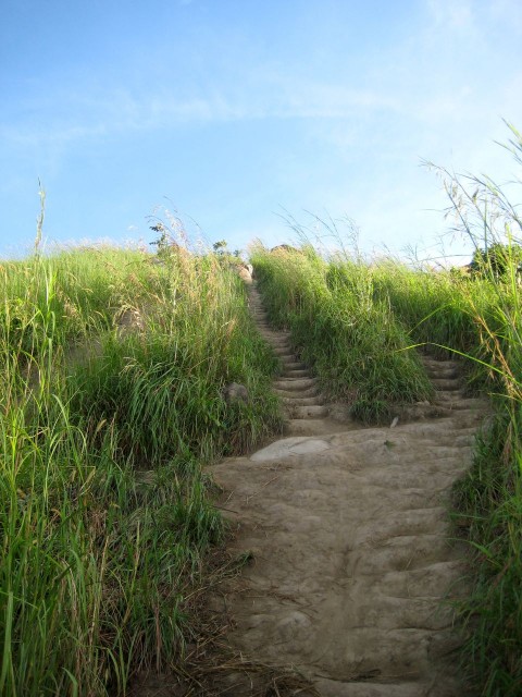
The slope leading to the 1st peak after coming out of the jungle.
View from the 3rd peak
View of the 4th peak from the 3rd peak. The rocks require the use of a rope.
View from the 4th peak. KL (including the twin towers) is visible on a clear day
Cooking our breakfast. Photo by J. Ng.

GPS Details

Download GPX, KMZ (Google Earth)
View on EveryTrail

Duration: 47 minutes 53 seconds
Length: 1.8km
Average Speed: 2.2km/h
Max elevation: 396m
Min elevation: 105m
Vertical Up: 320m
Vertical Down: 32m
Gunung Nuang (Attempt 1: Failed)

A failed attempt on the highest peak in Selangor due to time constraints.

DISCLAIMER: This post was written in 2012. Information may be out of date!

UPDATE 26 September 2012: I reached the summit on my 2nd attempt! Read the story HERE.

On 17 August 2012, I attempted to climb Gunung Nuang with 4 other friends. Gunung Nuang, the highest mountain in Selangor, is known to be a fairly difficult climb which usually takes a whole day. From the various blog posts I have read on Gunung Nuang, it doesn’t seem to be a particularly fun mountain to climb, being famous for never-ending muddy and slippery slopes, and very few nice views. While the 1493m peak isn’t nearly the highest in Malaysia, the challenge comes from starting at a low altitude of 190m.

The climb can be separated into a few sections: Start – Never Ending Road – Kem Lolo – Kem Pacat – Puncak Pengasih – Summit.

The weather had been rainy for a few days prior to our climb, so we went mentally prepared for leeches and muddy terrain. We left KL around 6am and started our hike just after 7am, as the skies were just starting to turn light. By the time we had hiked for 20 minutes, almost everyone had picked up hitchhikers: leeches. They would become a constant sight throughout the trip, both on the trail and on our legs. By the end, everyone had 5-10 bites, except myself, as I had decent leech protection on.

We reached the end of the “never-ending road” at 8.30am (1:15hrs hike) . Unfortunately, we took a wrong turn and ended up crossing the river twice, unnecessarily. The detour cost us almost half an hour, after which we arrived at Kem Lolo @ ~9.15am (~2:00hrs hike). After that, it was a long slippery road to Kem Pacat, which we reached at 11.10am (4:00hrs hike). Unfortunately, due to time constraints (one in our team had to be down by 6pm) and my pace being on the slow side, we realized that we would not make the peak in time to get back by 6pm, so me and a friend stopped at Kem Pacat. The other 3 left any unnecessary items behind and set off for the peak.

The 3 other climbers returned to Kem Pacat at 1.40pm, unfortunately not having made it to the top. There had been a fallen tree along the path which took a long time to clear. They reached Puncak Pengasih (~1480m) at ~12.30pm, and decided that they wouldn’t make it in time to the peak for the 6pm return time. Also, water supplies were running slightly low.

We all headed down, reaching the entrance just after 5pm. We were defeated by Nuang, mostly because of time constraints. I will be climbing it again, as I know I am capable of reaching the top. For now, Nuang can laugh at us, but we WILL defeat it!

Here’s the 5 of us who climbed that day. (I didn’t really take any photos, and didn’t mark any waypoints on my GPS, as I was tired and didn’t have enough time to do so anyway. Next time!)

GPS Details

Download GPX
View on Everytrail
View on WikiLoc

Total distance: 10km (to Puncak Pengasih)
Total time: 5 hours 15 minutes (to Puncak Pengasih)
Average speed: 1.7 km/h
Max elevation: 1481m
Min elevation: 190m
Vertical Up: 1609m

From Everytrail:

Story
Didn’t make it up to the summit. A few factors:

  • Heavy thunderstorms for previous days meant trail was very muddy and slippery
  • High humidity meant more sweating
  • Time constraints (had to make trip < 10hrs)
  • Not enough water
  • Not enough sleep previous night
  • Accidental detour near Kem Lolo

There were a ton of leeches.

Tips

  • Climb on a dry day
  • If you have a water filter, you can refill at Kem Lolo (5.8km from trailhead ~600m)
  • You can leave unneeded supplies at Kem Pacat (1100m) to make your summit attempt easier. Either mark your belongings or leave a few friends there. Collect your supplies on the way down.
  • DON’T leave trash around!!!
  • At the first river, don’t go down the steps to cross the river. Take the trail on the left to follow the big pipe.
  • Bring headlamps, you may end up climbing in the dark